Town of Madison, Wisconsin | |
|---|---|
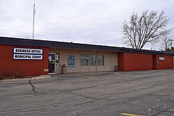
 Town of Madison Municipal Building | |
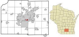
 Location in Dane County and the state of Wisconsin. | |
| Coordinates: 43°2′32″N 89°24′5″W / 43.04222°N 89.40139°W | |
| Country | |
| State | |
| County | Dane |
| Area | |
• Total | 1.5 sq mi (4 km2) |
| • Land | 1.48 sq mi (3.8 km2) |
| • Water | 0.01 sq mi (0.03 km2) |
| Elevation | 846 ft (258 m) |
| Population (2020) | |
• Total | 6,236 |
| • Density | 4,324.1/sq mi (1,669.5/km2) |
| Time zone | UTC-6 (Central (CST)) |
| • Summer (DST) | UTC-5 (CDT) |
| Area code | 608 |
| FIPS code | 55-48025[2] |
| GNIS feature ID | 1583626[1] |
The Town of Madison was located in Dane County, Wisconsin, United States. The town ceased to exist on October 31, 2022. Its final population was 6,236 at the 2020 United States census. The majority of the town's territory was situated along the Madison Beltline Highway, comprising several neighborhoods situated between the south side of the city of Madison, and the north side of the city of Fitchburg. The town also had territory on the north side of Madison near the border with Maple Bluff, as well as a few lots on the west side of Madison near Whitney Way. The Dane County Expo Center and Alliant Energy Center were situated within the Town of Madison. Despite its status as an unincorporated community, the Town of Madison provided a variety of services to its residents which typically would only be found in incorporated cities and villages, including trash and recycling services, police, fire and emergency medical services; sewer and water utilities; and three public parks.
- ^ a b "US Board on Geographic Names". United States Geological Survey. October 25, 2007. Retrieved January 31, 2008.
- ^ "U.S. Census website". United States Census Bureau. Retrieved January 31, 2008.

