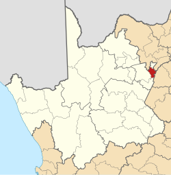
Magareng | |
|---|---|
 Location in the Northern Cape | |
| Coordinates: 28°10′S 24°50′E / 28.167°S 24.833°E | |
| Country | South Africa |
| Province | Northern Cape |
| District | Frances Baard |
| Seat | Warrenton |
| Wards | 6 |
| Government | |
| • Type | Municipal council |
| • Mayor | Neo Mase |
| Area | |
• Total | 1,542 km2 (595 sq mi) |
| Population (2011)[2] | |
• Total | 24,204 |
| • Density | 16/km2 (41/sq mi) |
| Racial makeup (2011) | |
| • Black African | 80.0% |
| • Coloured | 13.9% |
| • Indian/Asian | 0.7% |
| • White | 5.1% |
| First languages (2011) | |
| • Tswana | 67.2% |
| • Afrikaans | 21.2% |
| • Xhosa | 3.6% |
| • Sotho | 2.2% |
| • Other | 5.8% |
| Time zone | UTC+2 (SAST) |
| Municipal code | NC093 |
Magareng Municipality (Tswana: Mmasepala wa Magareng; Afrikaans: Magareng Munisipaliteit) is a local municipality within the Frances Baard District Municipality, in the Northern Cape province of South Africa.
Magareng is a Setswana name meaning "in the middle". The name reflects the geographic location of the municipality in relation to other areas.[4]
- ^ "Contact list: Executive Mayors". Government Communication & Information System. Archived from the original on 14 July 2010. Retrieved 22 February 2012.
- ^ a b "Statistics by place". Statistics South Africa. Retrieved 27 September 2015.
- ^ "Statistics by place". Statistics South Africa. Retrieved 27 September 2015.
- ^ South African Languages - Place names
