Magnolia, Ohio | |
|---|---|
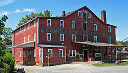
 The Magnolia Flouring Mill was established by the village's founder. | |
 Location of Magnolia, Ohio | |
 Location of Magnolia in Stark County | |
| Coordinates: 40°39′11″N 81°17′34″W / 40.65306°N 81.29278°W | |
| Country | United States |
| State | Ohio |
| Counties | Stark, Carroll |
| Area | |
• Total | 0.80 sq mi (2.07 km2) |
| • Land | 0.80 sq mi (2.07 km2) |
| • Water | 0.00 sq mi (0.00 km2) |
| Elevation | 988 ft (301 m) |
| Population (2020) | |
• Total | 1,013 |
| • Density | 1,267.83/sq mi (489.61/km2) |
| Time zone | UTC-5 (Eastern (EST)) |
| • Summer (DST) | UTC-4 (EDT) |
| ZIP code | 44643 |
| Area code | 330 |
| FIPS code | 39-46844[3] |
| GNIS feature ID | 2399224[2] |
| Website | www |
Magnolia is a village in Carroll and Stark counties in the U.S. state of Ohio. The population was 1,013 at the time of the 2020 census. It is part of the Canton–Massillon metropolitan area.
- ^ "ArcGIS REST Services Directory". United States Census Bureau. Retrieved September 20, 2022.
- ^ a b U.S. Geological Survey Geographic Names Information System: Magnolia, Ohio
- ^ "U.S. Census website". United States Census Bureau. Retrieved January 31, 2008.