| Mahanoy Creek | |
|---|---|
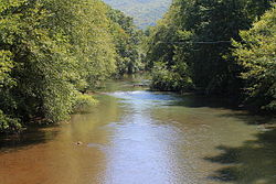
 Mahanoy Creek in Little Mahanoy Township, Northumberland County | |
 | |
| Location | |
| Country | United States |
| State | Pennsylvania |
| Counties | Northumberland and Schuylkill |
| Physical characteristics | |
| Source | |
| • location | Mahanoy Township, Pennsylvania |
| Mouth | |
• location | Susquehanna River in Jackson Township, Northumberland County, Pennsylvania |
• coordinates | 40°43′22″N 76°50′37″W / 40.7228°N 76.8435°W |
| Length | 51.6 mi (83.0 km) |
| Basin size | 157 sq mi (410 km2) |
| Discharge | |
| • average | Up to 320 cubic feet per second (9.1 m3/s) |
| Basin features | |
| Progression | Susquehanna River, Chesapeake Bay |
| Tributaries | |
| • left | Little Mahanoy Creek, Crab Run, Schwaben Creek |
| • right | North Mahanoy Creek, Shenandoah Creek, Zerbe Run |
Mahanoy Creek is a 51.6-mile-long (83.0 km)[1] tributary of the Susquehanna River in Northumberland and Schuylkill counties, Pennsylvania. There are at least 35 sources of acid mine drainage in the creek's watershed. Anthracite was mined in the upper part of the Mahanoy Creek watershed in the 19th and 20th centuries. Mahanoy Creek's tributaries include Schwaben Creek, Zerbe Run, Little Mahanoy Creek, Shenandoah Creek, and North Mahanoy Creek. Little Mahanoy Creek and Schwaben Creek are two streams in the watershed that are unaffected by acid mine drainage. Schwaben Creek has a higher number and diversity of fish species than the main stem.
There are two passive treatment systems in the Mahanoy Creek watershed by the Mahanoy Creek Watershed Association. Coal mining has been done in the watershed since the 19th century and continues to some extent in the 21st century. The watershed is in the Western Middle Anthracite Coal Field.
- ^ U.S. Geological Survey. National Hydrography Dataset high-resolution flowline data. The National Map Archived 2012-03-29 at the Wayback Machine, accessed August 8, 2011