Maharagama
මහරගම மகரகம | |
|---|---|
| Coordinates: 6°50′58″N 79°55′25″E / 6.84944°N 79.92361°E | |
| Country | Sri Lanka |
| Province | Western Province |
| District | Colombo District |
| Government | |
| • Type | Urban Council |
| Population (2012) | |
• Total | 195,355 |
| Time zone | UTC+5:30 (SLT) |
| Postal Code | 10280 [1] |
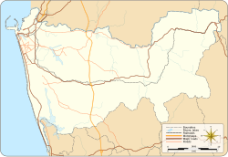
Maharagama is an outer suburb of Colombo, Sri Lanka on the High-Level (A4) Road about 10 km (6.2 mi) from the centre of the commercial capital. It developed rapidly in the 1980s as a dormitory suburb. Governed by the Maharagama Urban Council, the town possesses facilities like supermarkets, department stores, clothing, food and beverages shops to fulfill the needs of citizens.
There are number of bus routes passing the area and starting from the suburb that connect Maharagama to all the suburbs. The Sri Lanka Transport Board has a depot in Maharagama.
- ^ "Colombo District Postal Codes - Sri Lankan Postal Codes". Archived from the original on 12 October 2015. Retrieved 1 February 2016.
