Mahmudabad County
Persian: شهرستان محمودآباد | |
|---|---|
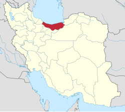
 Location of Mahmudabad County in Mazandaran province (top center, yellow) | |
 Location of Mazandaran province in Iran | |
| Coordinates: 36°36′N 52°19′E / 36.600°N 52.317°E[1] | |
| Country | |
| Province | Mazandaran |
| Capital | Mahmudabad |
| Districts | Central, Sorkhrud |
| Area | |
• Total | 262.80 km2 (101.47 sq mi) |
| Population (2016)[3] | |
• Total | 98,407 |
| • Density | 370/km2 (970/sq mi) |
| Time zone | UTC+3:30 (IRST) |
| Mahmudabad County can be found at GEOnet Names Server, at this link, by opening the Advanced Search box, entering "9207264" in the "Unique Feature Id" form, and clicking on "Search Database". | |
Mahmudabad County (Persian: شهرستان محمودآباد) is in Mazandaran province, Iran. Its capital is the city of Mahmudabad.[4]
- ^ OpenStreetMap contributors (22 October 2024). "Mahmudabad County" (Map). OpenStreetMap (in Persian). Retrieved 22 October 2024.
- ^ Management and Planning Organization of Mazandaran, 2006 [1]
- ^ Cite error: The named reference
2016 Mazandaran Provincewas invoked but never defined (see the help page). - ^ Habibi, Hassan (c. 2024) [Approved 5 June 1374]. Divisional changes in Hezar District of Amol County in Mazandaran province. lamtakam.com (Report) (in Persian). Ministry of the Interior, Council of Ministers. Proposal 1.4.42.5268; Letter 93808-907. Archived from the original on 15 January 2024. Retrieved 15 January 2024 – via Lam ta Kam.