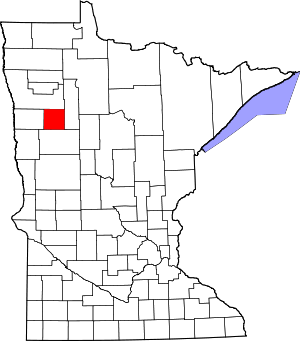
Mahnomen County | |
|---|---|
 | |
 Location within the U.S. state of Minnesota | |
 Minnesota's location within the U.S. | |
| Coordinates: 47°20′N 95°49′W / 47.33°N 95.81°W | |
| Country | |
| State | |
| Founded | December 27, 1906 |
| Named for | Ojibway word for wild rice |
| Seat | Mahnomen |
| Largest city | Mahnomen |
| Area | |
| • Total | 583 sq mi (1,510 km2) |
| • Land | 558 sq mi (1,450 km2) |
| • Water | 25 sq mi (60 km2) 4.3% |
| Population (2020) | |
| • Total | 5,411 |
| • Estimate (2023) | 5,280 |
| • Density | 9.7/sq mi (3.7/km2) |
| Time zone | UTC−6 (Central) |
| • Summer (DST) | UTC−5 (CDT) |
| Congressional district | 7th |
| Website | www |
Mahnomen County (/məˈnoʊmən/ mə-NOH-mən) is a county in the U.S. state of Minnesota. As of the 2020 census, the population was 5,411.[1] Its county seat is Mahnomen.[2]
The county is part of the White Earth Indian Reservation.[3] It is the only county in Minnesota entirely within an Indian reservation. Mahnomen, East Polk, and Becker counties constitute one of northwestern Minnesota's biggest cattle-raising areas.
- ^ "State & County QuickFacts". United States Census Bureau. Retrieved April 19, 2023.
- ^ "Find a County". National Association of Counties. Retrieved June 7, 2011.
- ^ "White Earth Indian Reservation" (United States Census Bureau map)