| Maianbar Sydney, New South Wales | |||||||||||||||
|---|---|---|---|---|---|---|---|---|---|---|---|---|---|---|---|
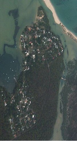
 Aerial image of Maianbar looking to the North. | |||||||||||||||
 | |||||||||||||||
| Population | 505 (2016 census)[1] | ||||||||||||||
| • Density | 1,740/km2 (4,510/sq mi) | ||||||||||||||
| Postcode(s) | 2230 | ||||||||||||||
| Elevation | 40 m (131 ft) | ||||||||||||||
| Area | 0.29 km2 (0.1 sq mi) | ||||||||||||||
| Location | 29 km (18 mi) south of Sydney CBD | ||||||||||||||
| LGA(s) | Sutherland Shire | ||||||||||||||
| State electorate(s) | Heathcote | ||||||||||||||
| Federal division(s) | Hughes | ||||||||||||||
| |||||||||||||||
Maianbar is a village on the outskirts of southern Sydney, in the state of New South Wales, Australia 29 kilometres south of the Sydney central business district. It is part of the Sutherland Shire.
Maianbar is adjacent to the village of Bundeena, less than kilometre away and linked by a bush track, and footbridge. It lies on the southern side of Port Hacking, opposite the suburbs of Burraneer, Dolans Bay, Port Hacking, Lilli Pilli and Cronulla. Maianbar is surrounded by the Royal National Park.
- ^ Australian Bureau of Statistics (27 June 2017). "Maianbar (State Suburb)". 2016 Census QuickStats. Retrieved 6 December 2018.
 Material was copied from this source, which is available under a Creative Commons Attribution 4.0 International License.