| Main Caucasian Range | |
|---|---|
| Главный Кавказский хребет კავკასიონის მთავარი წყალგამყოფი ქედი Baş Qafqaz silsiləsi | |
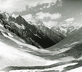
 View from the Chuchkhur Pass | |
| Highest point | |
| Peak | Shkhara |
| Elevation | 5,193 m (17,037 ft) |
| Coordinates | 43°00′02″N 43°06′44″E / 43.00056°N 43.11222°E |
| Dimensions | |
| Length | 1,200 km (750 mi) ESE/WNW |
| Width | 180 km (110 mi) NNE/SSW |
| Geography | |
| Countries | Russia, Georgia and Azerbaijan |
| Federal subjects | Abkhazia, Adygea, Krasnodar Krai, Karachay-Cherkessia, Kabardino-Balkaria, North Ossetia, Ingushetia, Chechnya and Dagestan |
| Range coordinates | 42°36′N 43°50′E / 42.600°N 43.833°E |
| Parent range | Greater Caucasus |
| Geology | |
| Rock age | Paleozoic |
The Main Caucasian Range[a] is a mountain range in the Russian Federation, Georgia and Azerbaijan. It is the dividing range of the Greater Caucasus.
The protected areas of the range are the Teberda Nature Reserve, Kabardino-Balkaria Nature Reserve and the North Ossetia Nature Reserve.[1][2][3]
Cite error: There are <ref group=lower-alpha> tags or {{efn}} templates on this page, but the references will not show without a {{reflist|group=lower-alpha}} template or {{notelist}} template (see the help page).

