This article has multiple issues. Please help improve it or discuss these issues on the talk page. (Learn how and when to remove these messages)
|
| Yarra Trail | |
|---|---|
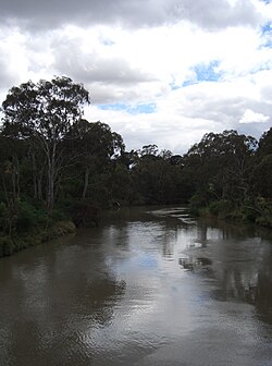
 The Yarra River, as seen from Kanes Bridge, near the Studley Park boathouse. | |
| Length | About 38km from Princes Bridge to Mullum Mullum Creek Trail |
| Location | Melbourne, Victoria, Australia |
| Difficulty | Easy to medium |
| Hazards | Some blind corners, steep drop into the river. In winter, on the north bank near the city, ice can form on the floating pontoons. A steep corkscrew path used to cross under Banksia St. |
| Surface | Mostly Concrete & bitumen path, well-formed gravel along river flats. |
| Hills | Gipps Street steps. Bumpy metal joints and slippery ramps on the Northbank promenade |
| Water | Regular water fountains in lower reaches, tap at "Yarra Marsh" (Heidelberg) |
| Train(s) | Flinders Street, Clifton Hill, Heidelberg and Eltham (see Diamond Creek Trail) |
The Main Yarra Trail, also known as the Yarra Trail is a shared-use path for cyclists and pedestrians, which follows the Yarra River through the northeastern suburbs of Melbourne, Victoria, Australia.[1][2]
The trail follows the river from near its mouth, through the city and suburbs to Westerfolds Park and Eltham. The Capital City Trail uses the same path up to Dights Falls, where it continues up the Merri Creek Trail as part of its loop around the city.[3]
- ^ VicRoads - Bicycle Facilities Map Archived 2007-02-19 at the Wayback Machine
- ^ Melbourne and Geelong's shared paths in Google Earth
- ^ "Walking tracks and bike paths | Melbourne Water". www.Melbournewater.com.au. Archived from the original on 6 January 2023. Retrieved 6 January 2023.