| Maitland New South Wales | |||||||||
|---|---|---|---|---|---|---|---|---|---|
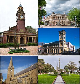
 From top, left to right: Maitland Court House, The Levee, Maitland Post Office, St Mary's the Virgin Anglican Church, Citizens Memorial at Maitland Park | |||||||||
| Coordinates | 32°43′S 151°33′E / 32.717°S 151.550°E | ||||||||
| Population | 89,597 (2021 census)[1] | ||||||||
| • Density | 230/km2 (600/sq mi) | ||||||||
| Established | 1820 | ||||||||
| Postcode(s) | 2320 | ||||||||
| Elevation | 3 m (10 ft) | ||||||||
| Area | 392 km2 (151.4 sq mi)[2] | ||||||||
| Time zone | AEST (UTC+10) | ||||||||
| • Summer (DST) | AEDT (UTC+11) | ||||||||
| Location | |||||||||
| LGA(s) | Maitland City Council | ||||||||
| Region | Hunter | ||||||||
| County | Northumberland | ||||||||
| Parish | Maitland | ||||||||
| State electorate(s) | Maitland | ||||||||
| Federal division(s) | |||||||||
| |||||||||
Maitland (/ˈmeɪtlənd/) is a city in the Hunter Valley of New South Wales, Australia and the seat of Maitland City Council, situated on the Hunter River approximately 166 kilometres (103 mi) by road north of Sydney and 35 km (22 mi) north-west of Newcastle. It is on the New England Highway approximately 17 km (11 mi) from its origin at Hexham.
At the 2021 census it had approximately 89,597 inhabitants, spread over an area of 392 square kilometres (151 sq mi), with most of the population located in a strip along the New England Highway between the suburbs of Lochinvar and Thornton respectively. The city centre is located on the right bank of the Hunter River, protected from moderate potential flooding by a levee.
Surrounding areas include the cities of Cessnock and Singleton local government areas.
- ^ Australian Bureau of Statistics (28 June 2022). "Maitland (NSW)(Urban Centre/Locality)". 2021 Census QuickStats. Retrieved 16 December 2023.
- ^ Australian Bureau of Statistics (31 October 2012). "2011 Community Profiles: Maitland (Local Government Area)". 2011 Census of Population and Housing. Retrieved 6 October 2012.
- ^ a b c "Maitland Visitors Centre". Climate statistics for Australian locations. Bureau of Meteorology. 2016. Retrieved 7 September 2018.
