Maitum
Maitom | |
|---|---|
| Municipality of Maitum | |
| Other transcription(s) | |
| • Jawi | مايتم |
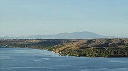
 Coastal view of Maitum | |
| Etymology: Black stone | |
| Motto: Masaganang Maitum | |
 Map of Sarangani with Maitum highlighted | |
Location within the Philippines | |
| Coordinates: 6°02′N 124°29′E / 6.03°N 124.48°E | |
| Country | Philippines |
| Region | Soccsksargen |
| Province | Sarangani |
| District | Lone district |
| Founded | May 7, 1959 |
| Barangays | 19 (see Barangays) |
| Government | |
| • Type | Local Government Unit |
| • Mayor | Alexander Bryan B. Reganit |
| • Vice Mayor | Tito T. Balazon |
| • Representative | Steve Solon |
| • Municipal Council | Members |
| • Electorate | 29,218 voters (2022) |
| Area | |
• Total | 290.66 km2 (112.22 sq mi) |
| Elevation | 62 m (203 ft) |
| Highest elevation | 565 m (1,854 ft) |
| Lowest elevation | 0 m (0 ft) |
| Population (2020 census)[3] | |
• Total | 44,185 |
| • Density | 150/km2 (390/sq mi) |
| • Households | 10,805 |
| Economy | |
| • Income class | 2nd municipal income class |
| • Poverty incidence | 26.65 |
| • Revenue | ₱ 192.8 million (2020) |
| • Assets | ₱ 534.7 million (2020) |
| • Expenditure | ₱ 177 million (2020) |
| • Liabilities | ₱ 107.1 million (2020) |
| Service provider | |
| • Electricity | South Cotabato 2 Electric Cooperative (SOCOTECO 2) |
| Time zone | UTC+8 (PST) |
| ZIP code | 9515 |
| PSGC | |
| IDD : area code | +63 (0)83 |
| Native languages | Cebuano Tboli Maguindanao Blaan Tagalog |
| Website | www |
Maitum, officially the Municipality of Maitum (Cebuano: Lungsod sa Maitum; Maguindanaon: Inged nu Maitum, Jawi: ايڠد نو مايتم; Tagalog: Bayan ng Maitum), is a 2nd class municipality in the province of Sarangani, Philippines. According to the 2020 census, it has a population of 44,185 people, making it the least populated municipality in the province.[3]
It is bordered on the west by the province of Sultan Kudarat, on the east by the municipality of Kiamba, on the north by the province of South Cotabato, and the south by the Celebes Sea.
- ^ Municipality of Maitum | (DILG)
- ^ "2015 Census of Population, Report No. 3 – Population, Land Area, and Population Density" (PDF). Philippine Statistics Authority. Quezon City, Philippines. August 2016. ISSN 0117-1453. Archived (PDF) from the original on May 25, 2021. Retrieved July 16, 2021.
- ^ a b Census of Population (2020). "Region XII (Soccsksargen)". Total Population by Province, City, Municipality and Barangay. Philippine Statistics Authority. Retrieved 8 July 2021.
- ^ "PSA Releases the 2021 City and Municipal Level Poverty Estimates". Philippine Statistics Authority. 2 April 2024. Retrieved 28 April 2024.


