This article needs additional citations for verification. (September 2016) |
| Makgadikgadi Pan | |
|---|---|
 The Makgadikgadi pans are clearly visible to the right of the dark-green broom-shaped Okavango Delta in this satellite image of Botswana | |
 The main water source is the Nata River, called Amanzanyama in Zimbabwe, where it rises at Sandown about 37 mi (59.5 km) from Bulawayo. A smaller amount of water is supplied by the Boteti River from the Okavango delta. | |
| Geography | |
| Location | Okavango Delta |
| Country | Botswana |
| Coordinates | 20°48′S 25°20′E / 20.800°S 25.333°E |
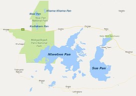
The Makgadikgadi Pan /məˈkædiˈkædi/ (Tswana pronunciation [makχʰadiˈkχʰaːdi][needs tone]), a salt pan situated in the middle of the dry savanna of north-eastern Botswana, is one of the largest salt flats in the world. The pan is all that remains of the formerly enormous Lake Makgadikgadi, which once covered an area larger than Switzerland, but dried up tens of thousands of years ago. Recent studies of human mitochondrial DNA suggest that modern Homo sapiens first began to evolve in this region some 200,000 years ago, when it was a vast, exceptionally fertile area of lakes, rivers, marshes, woodlands and grasslands especially favorable for habitation by evolving hominins and other mammals.[1]
- ^ Chan, E. K. F., 2019. Human origins in a southern African palaeo-wetland and first migrations. Nature doi: 10.1038/s41586-019-1714-1