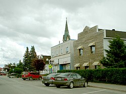
Malartic | |
|---|---|
 | |
| Motto(s): Ma ville, ma famille, ma fierté ("My town, my family, my pride") | |
 Location within La Vallée-de-l'Or RCM | |
| Coordinates: 48°08′N 78°08′W / 48.133°N 78.133°W[1] | |
| Country | Canada |
| Province | Quebec |
| Region | Abitibi-Témiscamingue |
| RCM | La Vallée-de-l'Or |
| Settled | 1928 |
| Constituted | April 28, 1939 |
| Government | |
| • Mayor | Martin Ferron[2] |
| • Federal riding | Abitibi—Baie-James— Nunavik—Eeyou |
| • Prov. riding | Abitibi-Est |
| Area | |
• Total | 158.54 km2 (61.21 sq mi) |
| • Land | 147.45 km2 (56.93 sq mi) |
| Population (2021)[4] | |
• Total | 3,355 |
| • Density | 22.8/km2 (59/sq mi) |
| • Pop (2016-21) | |
| • Dwellings | 1,635 |
| Time zone | UTC−5 (EST) |
| • Summer (DST) | UTC−4 (EDT) |
| Postal code(s) | |
| Area code | 819 |
| Highways | |
| Website | ville |
Malartic is a town on the Malartic River in northwestern Quebec, Canada, in the La Vallée-de-l'Or Regional County Municipality. It is located about 80 kilometres (50 mi) east of the centre of Rouyn-Noranda along Quebec Route 117 and the Canadian National Railway.
In addition to the main population centre of Malartic, the municipality also includes the smaller settlement of Norrie (48°7′44″N 78°4′51″W / 48.12889°N 78.08083°W).[5]
- ^ Cite error: The named reference
toponymiewas invoked but never defined (see the help page). - ^ "Ville de Malartic » Membres du conseil". Archived from the original on 2019-07-16. Retrieved 2019-07-16.
- ^ a b "Répertoire des municipalités: Geographic code 89015". www.mamh.gouv.qc.ca (in French). Ministère des Affaires municipales et de l'Habitation.
- ^ a b "Malartic, Quebec (Code 2489015) Census Profile". 2021 census. Government of Canada - Statistics Canada.
- ^ "Norrie". Geographical Names Data Base. Natural Resources Canada. Retrieved 8 November 2023.
