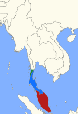
 Location of the Malay Peninsula | |
| Geography | |
|---|---|
| Location | Southeast Asia |
| Coordinates | 7°00′N 100°00′E / 7.000°N 100.000°E |
| Adjacent to | Indian Ocean, Pacific Ocean |
| Area | 242,363.8 km2 (93,577.2 sq mi) |
| Highest elevation | 2,187 m (7175 ft) |
| Highest point | Mount Tahan |
| Administration | |
| Peninsular Malaysia | |
| Largest settlement | Kuala Lumpur |
| Region | Tanintharyi |
| District | Kawthaung |
| Largest settlement | Kawthaung |
| Southern Thailand | |
| Largest settlement | Hat Yai |
The Malay Peninsula[a] is located in Mainland Southeast Asia. The landmass runs approximately north–south, and at its terminus, it is the southernmost point of the Asian continental mainland. The area contains Peninsular Malaysia, Southern Thailand, and the southernmost tip of Myanmar (Kawthaung). The island country of Singapore also has historical and cultural ties with the region.
The Titiwangsa Mountains are part of the Tenasserim Hills system and form the backbone of the peninsula and the southernmost section of the central cordillera, which runs from Tibet through the Kra Isthmus, the peninsula's narrowest point, into the Malay Peninsula.[1] The Strait of Malacca separates the Malay Peninsula from the Indonesian island of Sumatra, and the south coast is separated from the island of Singapore by the Straits of Johor.
Cite error: There are <ref group=lower-alpha> tags or {{efn}} templates on this page, but the references will not show without a {{reflist|group=lower-alpha}} template or {{notelist}} template (see the help page).
- ^ The Physical Geography of Southeast Asia, Avijit Gupta