Maldegem | |
|---|---|
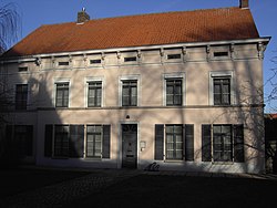
 Maldegem rectory | |
| Coordinates: 51°12′N 03°26′E / 51.200°N 3.433°E | |
| Country | |
| Community | Flemish Community |
| Region | Flemish Region |
| Province | East Flanders |
| Arrondissement | Eeklo |
| Government | |
| • Mayor | Koenraad De Ceuninck (CD&V) |
| • Governing party/ies | CD&V, N-VA, Groen |
| Area | |
• Total | 95.63 km2 (36.92 sq mi) |
| Population (2018-01-01)[1] | |
• Total | 23,689 |
| • Density | 250/km2 (640/sq mi) |
| Postal codes | 9990-9992 |
| NIS code | 43010 |
| Area codes | 050 |
| Website | www.maldegem.be |
Maldegem (Dutch pronunciation: [ˈmɑldəɣɛm]), earlier spelled Maldeghem, is a municipality located in the Belgian province of East Flanders. The municipality comprises the villages of Maldegem, Adegem and Middelburg. Kleit and Donk have always been separate hamlets of Maldegem. On 1 January 2018, Maldegem had a total population of 23,689. The total area is 94.64 square kilometres (36.54 sq mi) which gives a population density of 250 inhabitants per km2.
The Stoomcentrum Maldegem is located at the former NMBS railway station at Maldegem.
- ^ "Wettelijke Bevolking per gemeente op 1 januari 2018". Statbel. Retrieved 9 March 2019.


