| Malheur National Wildlife Refuge | |
|---|---|
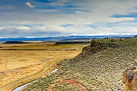
 A view of Steens Mountain from an overlook located in the Malheur National Wildlife Refuge | |
| Location | 30 miles (48 km) south of Burns, Harney County, Oregon, United States |
| Coordinates | 43°15′57″N 118°50′39″W / 43.26583°N 118.84417°W[1] |
| Area | 293.37 sq mi (759.8 km2) |
| Elevation | 4,121 ft (1,256 m) |
| Established | 1908 |
| Website | Malheur NWR |
Malheur National Wildlife Refuge is a National Wildlife Refuge located roughly 30 miles (48 km) south of the city of Burns in Oregon's Harney Basin. Administered by the United States Fish and Wildlife Service, the refuge area is roughly T-shaped with the southernmost base at Frenchglen, the northeast section at Malheur Lake and the northwest section at Harney Lake.
The refuge was created in 1908 by order of President Theodore Roosevelt to protect habitat for diverse waterfowl and migratory birds, and grew to encompass 187,757 acres (760 km2; 293 sq mi) of public lands. A popular site for birding, fishing, hunting and hiking, the refuge gained widespread attention in early 2016 after its headquarters complex was occupied by armed anti-government protesters.
- ^ "Malheur National Wildlife Refuge". Geographic Names Information System (GNIS). United States Geological Survey. November 28, 1980. Retrieved August 15, 2009.
