| Malibu Creek Malaga Creek Maliba Sequit Creek Malibo Creek Topanga Malibu Sequit Creek | |
|---|---|
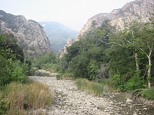
 Malibu Creek, dry river bed, with the Goat Buttes in the background | |
| Location | |
| Country | United States |
| State | California |
| Region | Los Angeles County |
| Physical characteristics | |
| Source | |
| • location | 4 mi (6 km) |
| • coordinates | 34°07′22″N 118°47′38″W / 34.12278°N 118.79389°W[1] |
| Source confluence | Triunfo Creek and Lobo Canyon Creek |
| • elevation | 760 ft (230 m) |
| Mouth | Malibu Lagoon then Santa Monica Bay, Pacific Ocean |
• location | Malibu, California |
• coordinates | 34°01′54″N 118°40′47″W / 34.03167°N 118.67972°W[1] |
• elevation | 3 ft (0.91 m)[1] |
| Basin features | |
| Tributaries | |
| • left | Medea Creek, Las Virgenes Creek, Cold Creek |
Malibu Creek is a year-round stream in western Los Angeles County, California. It drains the southern Conejo Valley and Simi Hills, flowing south through the Santa Monica Mountains, and enters Santa Monica Bay in Malibu. The Malibu Creek watershed drains 109 square miles (280 km2) and its tributary creeks reach as high as 3,000 feet (910 m) into Ventura County.[2] The creek's mainstem begins south of Westlake Village at the confluence of Triunfo Creek and Lobo Canyon Creek, and flows 13.4 miles (21.6 km)[3] to Malibu Lagoon.

Malibu Canyon is a chief pass through the mountains, and Malibu Canyon Road is a major north–south route connecting the coast to the inland valley. Malibu Creek starts at Malibou Lake, which is held back by the Malibu Lake Dam. Further downstream, the creek waterfalls 100 feet (30 m) over the Rindge Dam, then carves its final path into Malibu Lagoon.
- ^ a b c U.S. Geological Survey Geographic Names Information System: Malibu Creek
- ^ "Malibu Creek Watershed". Malibu Creek Watershed Council. Archived from the original on April 8, 2010. Retrieved June 13, 2010.
- ^ U.S. Geological Survey. National Hydrography Dataset high-resolution flowline data. The National Map Archived 2012-03-29 at the Wayback Machine, accessed March 16, 2011
