| Malpasset Dam | |
|---|---|
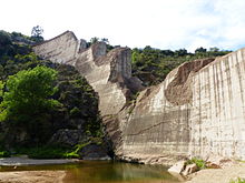
 The ruins of the dam 2014 | |
| Official name | French: Barrage de Malpasset |
| Location | France |
| Coordinates | 43°30′43.48″N 6°45′23.40″E / 43.5120778°N 6.7565000°E |
| Construction began | April 1952 |
| Opening date | 1954 |
| Demolition date | 2 December 1959 |
| Construction cost | 580 million francs (by 1955 prices) |
| Designed by | André Coyne |
| Owner(s) | Département Var (59) |
| Dam and spillways | |
| Type of dam | arch dam |
| Impounds | Reyran River |
| Height | 66 metres (72 yd) |
| Length | 222 metres (243 yd) |
| Width (crest) | 1.5 metres (1.6 yd) |
| Width (base) | 6.78 metres (7.41 yd) |
| Reservoir | |
| Total capacity | 50 million cubic metres (65×106 cu yd) |
| Website https://frejus-tourist-office.com/discover/barrage-de-malpasset/ | |
The Malpasset Dam was an arch dam (convex surface facing upstream) on the Reyran River, north of Fréjus on the French Riviera. It collapsed on 2 December 1959, killing 423 people in the resulting flood. The breach was caused by a tectonic fault in the impermeable rock base, which had been inadequately surveyed. Nearby road-building works, using explosives, may also have contributed to the disaster.
