| Mammoth Mountain | |
|---|---|
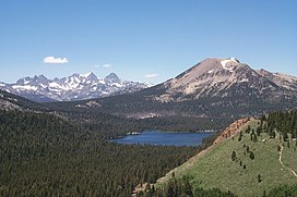
 Mammoth Mountain from the south, with Ritter Range behind | |
| Highest point | |
| Elevation | 11,059 ft (3,371 m) NAVD 88[1] |
| Prominence | 1,647 ft (502 m)[2] |
| Listing | Mountains of California |
| Coordinates | 37°37′50″N 119°01′57″W / 37.630626492°N 119.032625631°W[1] |
| Geography | |
| Country | United States |
| State | California |
| Counties | |
| Protected area | Inyo National Forest |
| Parent range | Sierra Nevada |
| Topo map | USGS Mammoth Mountain |
| Geology | |
| Rock age | About 50,000 to 200,000 years |
| Mountain type | Lava dome complex[3] |
| Volcanic arc | Long Valley Caldera |
| Last eruption | 1260 ± 40 years[3] |
| Climbing | |
| Easiest route | Gondola[4] |
Mammoth Mountain is a lava dome complex partially located within the town of Mammoth Lakes, California, in the Inyo National Forest of Madera and Mono Counties.[3] It is home to a large ski area primarily on the Mono County side.
Mammoth Mountain was formed in a series of eruptions that ended 57,000 years ago. Mammoth still produces hazardous volcanic gases that kill trees.[5]
- ^ a b "706 702 2=Mammoth". NGS Data Sheet. National Geodetic Survey, National Oceanic and Atmospheric Administration, United States Department of Commerce. Retrieved 2014-01-16.
- ^ "Mammoth Mountain, California". Peakbagger.com. Retrieved 2009-08-03.
- ^ a b c Cite error: The named reference
SIwas invoked but never defined (see the help page). - ^ Cite error: The named reference
NYT_SKIwas invoked but never defined (see the help page). - ^ Cite error: The named reference
latimes2006was invoked but never defined (see the help page).

