Manatee County | |
|---|---|
 Manatee County Administration Building | |
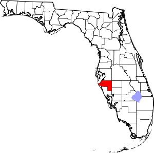
 Location within the U.S. state of Florida | |
 Florida's location within the U.S. | |
| Coordinates: 27°29′N 82°22′W / 27.48°N 82.36°W | |
| Country | |
| State | |
| Founded | January 9, 1855 |
| Named for | Florida manatee |
| Seat | Bradenton |
| Largest city | Bradenton |
| Area | |
• Total | 893 sq mi (2,310 km2) |
| • Land | 743 sq mi (1,920 km2) |
| • Water | 150 sq mi (400 km2) 16.8% |
| Population (2020) | |
• Total | 399,710 |
| • Density | 538/sq mi (208/km2) |
| Time zone | UTC−5 (Eastern) |
| • Summer (DST) | UTC−4 (EDT) |
| Area code | 941 |
| Congressional district | 16th |
| Website | www |
Manatee County is a county in the U.S. state of Florida. As of the 2020 U.S. Census, the population was 399,710.[1] Manatee County is part of the North Port-Bradenton-Sarasota, Florida Metropolitan Statistical Area. Its county seat and largest city is Bradenton.[2] The county was created in 1855 and named for the Florida manatee,[3] Florida's official marine mammal. Features of Manatee County include access to the southern part of the Tampa Bay estuary, the Sunshine Skyway Bridge, and the Manatee River.
- ^ "State & County QuickFacts". United States Census Bureau. Retrieved February 20, 2020.
- ^ "Find a County". National Association of Counties. Retrieved June 7, 2011.
- ^ Publications of the Florida Historical Society. Florida Historical Society. 1908. p. 33.

