You can help expand this article with text translated from the corresponding article in German. (November 2010) Click [show] for important translation instructions.
|
Manatuto | |
|---|---|
City | |
 | |
| Coordinates: 8°30′44″S 126°00′57″E / 8.51222°S 126.01583°E | |
| Country | |
| Municipality | Manatuto |
| Administrative post | Manatuto |
| Area | |
• Total | 271.38 km2 (104.78 sq mi) |
| Elevation | 0 m (0 ft) |
| Population (2010) | |
• Total | 3,692 |
| • Density | 14/km2 (35/sq mi) |
| Time zone | UTC+09:00 (TLT) |
| Climate | BSh |
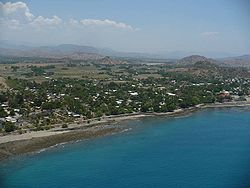
Manatuto is a city in Manatuto Municipality, East Timor.
Manatuto Vila has 3,692 inhabitants (Census 2015) and is capital of the subdistrict and district Manatuto. It is on the north coast of Timor, 64 km (40 mi) (about 50 km (31 mi) as the crow flies[1]: 1 ) east of Dili, the national capital, on the way to Baucau. The capital is known for its salt production and abundance of tamarind.
- ^ District Capitals Water Supply Project: Initial Environmental Examination of the Expansion, Rehabilitation and Operation and Maintenance of Manatuto Water Supply Systems (PDF) (Report). Ministry of Infrastructure for the Asian Development Bank. September 2011. TIM 44130-02. Retrieved 9 June 2022.
