Mancherial district | |
|---|---|
 | |
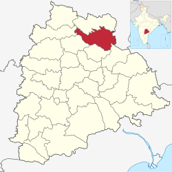
 Location in Telangana | |
| Coordinates (Mancherial): 18°52′17″N 79°26′40″E / 18.871454°N 79.444361°E | |
| Country | India |
| State | Telangana |
| Division | Mancherial |
| Headquarters | Mancherial |
| Mandalas | 18 |
| Government | |
| • District collector | Sri. Kumar Deepak, IAS |
| • Parliament Constituencies | Peddapalli |
| • Assembly constituencies | Mancherial,Chennur,Bellampalli |
| • MP | Vamsi Krishna Gaddam |
| Area | |
• Total | 4,016 km2 (1,551 sq mi) |
| Population (2011) | |
• Total | 807,037 |
| • Density | 200/km2 (520/sq mi) |
| • Urban | 353,847 |
| Time zone | UTC+05:30 (IST) |
| Vehicle registration | TG–19[1] |
| Major highways | NH 63, SH1Rajiv rahadari NH 363, NH163G Mancherial- Vijayawada GFH |
| Website | mancherial |
Mancherial district is a district located in the northern region of the Indian state of Telangana.[2][3] The district comprises 18 mandals and two revenue divisions – Mancherial and Bellampalli. The district headquarters is located at Mancherial town.[4] It is surrounded by Komaram Bheem, Nirmal, Jagtial, Peddapalli and Bhupalpally districts of Telangana and with Maharashtra state.
- ^ "Telangana New Districts Names 2016 Pdf TS 31 Districts List". Timesalert.com. 11 October 2016. Retrieved 11 October 2016.
- ^ "Komaram Bheem district" (PDF). Chief Commissioner of Land Administration. Archived from the original (PDF) on 9 September 2016. Retrieved 22 August 2016.
- ^ "New districts map". newdistrictsformation.telangana.gov.in. Retrieved 22 August 2016.[permanent dead link]
- ^ "Mancherial Official Page". The Official Website of the Mancherial District. Retrieved 3 March 2017.