Mandal
Vester-Risør (historic) | |
|---|---|
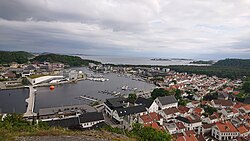
 View of the town | |
| Coordinates: 58°01′36″N 07°27′12″E / 58.02667°N 7.45333°E | |
| Country | Norway |
| Region | Southern Norway |
| County | Agder |
| Municipality | Lindesnes |
| Established as | |
| Ladested | 1632 [1] |
| Kjøpstad | 1921 |
| Area | |
• Total | 6.63 km2 (2.56 sq mi) |
| Elevation | 1 m (3 ft) |
| Population (2019)[2] | |
• Total | 11,053 |
| • Density | 1,667/km2 (4,320/sq mi) |
| Demonym | Mandalitt |
| Time zone | UTC+01:00 (CET) |
| • Summer (DST) | UTC+02:00 (CEST) |
| Post Code | 4501 Mandal |
Mandal is a town in Lindesnes municipality in Agder county, Norway. Mandal is the fourth largest town in Agder as well as the administrative centre of Lindesnes municipality. It is located at the mouth of the river Mandalselva at the southern end of the Mandalen valley. The 6.63-square-kilometre (1,640-acre) town has a population (2019) of 11,053 and a population density of 1,667 inhabitants per square kilometre (4,320/sq mi).[2] In Norway, Mandal is considered a by which can be translated as either a "town" or "city" in English.
The town lies along the European route E39 highway, about 40 kilometres (25 mi) southwest of the town of Kristiansand and about 60 kilometres (37 mi) southeast of the town of Flekkefjord. Mandal has a few suburban villages lying just outside its borders such as Ime immediately to the east and Sånum to the southwest. The village of Krossen lies about 10 kilometres (6.2 mi) to the north, along the Mandalselva river.
- ^ Cite error: The named reference
MBHwas invoked but never defined (see the help page). - ^ a b c Statistisk sentralbyrå (1 January 2019). "Urban settlements. Population and area, by municipality".
- ^ "Mandal (Vest-Agder)". yr.no. Archived from the original on 2018-10-06. Retrieved 2016-12-26.

