Mandla district | |
|---|---|
Kanha National Park Moti Mahal | |
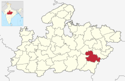
 Location of Mandla district in Madhya Pradesh | |
| Country | |
| State | Madhya Pradesh |
| Division | Jabalpur |
| Headquarters | Mandla |
| Tehsils | 6
Tehsil 1 Bichhiya 2 Mandla 3 Ghughari 4 Nainpur 5 Niwas 6 Narayanganj |
| Government | |
| • District Magistrate | Dr. Saloni Sidana |
| • Lok Sabha constituencies | Mandla |
| • Vidhan Sabha constituencies | 3 |
| Area | |
• Total | 8,771 km2 (3,387 sq mi) |
| Population (2011) | |
• Total | 1,054,905 |
| • Density | 120/km2 (310/sq mi) |
| Demographics | |
| • Literacy | 100 per cent |
| • Sex ratio | 1008 |
| Time zone | UTC+05:30 (IST) |
| Major highways | 12A(NH 30) |
| Website | mandla |
Mandla District is a district of Madhya Pradesh in central India.[1] The town of Mandla is the administrative headquarters of the district. It is part of Jabalpur Division.[2]
The district has an area of 8771 km², and a population of 779,414. It has 9 development blocks, 6 tehsils, and 1214 villages. It lies in the Mahakoshal region, and most of the district lies in the basin of the Narmada River.
- ^ "Madhya Pradesh: Mandla becomes 100% literate tribal district". The Times of India. 2022-08-15. ISSN 0971-8257. Retrieved 2023-08-29.
- ^ "Mandla district".


