Mangatarem | |
|---|---|
| Municipality of Mangatarem | |
 | |
| Etymology: lit. Mango Orchard | |
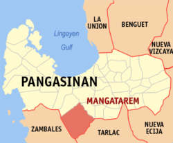
 Map of Pangasinan with Mangatarem highlighted | |
Location within the Philippines | |
| Coordinates: 15°47′15″N 120°17′32″E / 15.7874°N 120.2921°E | |
| Country | Philippines |
| Region | Ilocos Region |
| Province | Pangasinan |
| District | 2nd district |
| Founded | 1837 |
| Barangays | 82 (see Barangays) |
| Government | |
| • Type | Sangguniang Bayan |
| • Mayor | Ramil P. Ventenilla |
| • Vice Mayor | Michael Mon R. Punzal |
| • Representative | Mark Oppen Cojuangco |
| • Municipal Council | Members |
| • Electorate | 54,377 voters (2022) |
| Area | |
| • Total | 317.50 km2 (122.59 sq mi) |
| Elevation | 29 m (95 ft) |
| Highest elevation | 291 m (955 ft) |
| Lowest elevation | 8 m (26 ft) |
| Population (2020 census)[3] | |
| • Total | 79,323 |
| • Density | 250/km2 (650/sq mi) |
| • Households | 19,840 |
| Economy | |
| • Income class | 1st municipal income class |
| • Poverty incidence | 21.89 |
| • Revenue | ₱ 259.9 million (2020) |
| • Assets | ₱ 571.3 million (2020) |
| • Expenditure | ₱ 263.2 million (2020) |
| • Liabilities | ₱ 137.6 million (2020) |
| Service provider | |
| • Electricity | Central Pangasinan Electric Cooperative (CENPELCO) |
| Time zone | UTC+8 (PST) |
| ZIP code | 2413 |
| PSGC | |
| IDD : area code | +63 (0)75 |
| Native languages | Pangasinan Ilocano Tagalog |
Mangatarem, officially the Municipality of Mangatarem (Pangasinan: Baley na Mangatarem; Ilocano: Ili ti Mangatarem; Tagalog: Bayan ng Mangatarem), is a 1st class municipality in the province of Pangasinan, Philippines. According to the 2020 census, it has a population of 79,323 people.[3]
The Municipality is home to the Manleluag Hot Spring Protected Landscape located in Barangay Malabobo near the southern boundary of the municipality.
Mangatarem is 29 kilometers (18 mi) from provincial capital Lingayen and 177 kilometers (110 mi) from Manila.
- ^ Municipality of Mangatarem | (DILG)
- ^ "2015 Census of Population, Report No. 3 – Population, Land Area, and Population Density" (PDF). Philippine Statistics Authority. Quezon City, Philippines. August 2016. ISSN 0117-1453. Archived (PDF) from the original on May 25, 2021. Retrieved July 16, 2021.
- ^ a b Census of Population (2020). "Region I (Ilocos Region)". Total Population by Province, City, Municipality and Barangay. Philippine Statistics Authority. Retrieved 8 July 2021.
- ^ "PSA Releases the 2021 City and Municipal Level Poverty Estimates". Philippine Statistics Authority. 2 April 2024. Retrieved 28 April 2024.


