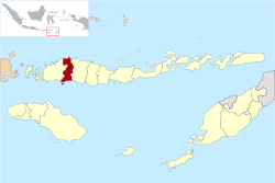
Manggarai Regency
Kabupaten Manggarai | |
|---|---|
 Location within East Nusa Tenggara | |
| Coordinates: 8°36′46″S 120°27′45″E / 8.6127°S 120.4626°E | |
| Country | |
| Province | |
| Capital | Ruteng |
| Government | |
| • Regent | Deno Kamelus |
| • Vice Regent | Victor Madur |
| Area | |
| • Total | 518.93 sq mi (1,344.03 km2) |
| Population (mid 2023 estimate)[1] | |
| • Total | 337,079 |
| • Density | 650/sq mi (250/km2) |
| Area code | (+62) 385 |
| Website | manggaraikab |
Manggarai Regency is a regency in East Nusa Tenggara province of Indonesia, situated on the island of Flores. Established in 1958[2] to encompass the 6,924.18 km2 area of the lands of the indigenous Manggarai people (speaking the various dialects of the Rombo Manggarai language), the regency was reduced in area (by over 80%) and in population by the separation of the more western districts to form West Manggarai Regency on 25 February 2003 and of the more eastern districts to form East Manggarai Regency on 17 July 2007.
The area of the residual Manggarai Regency is 1,344.03 km2 and its population was 292,037 at the 2010 census[3] and 312,855 at the 2020 census;[4] the official estimate as at mid 2023 was 337,079.[1] The capital of the regency is the town of Ruteng (which equates to Langke Rembong District, and NOT to the rural Ruteng District).
The Liang Bua archeological site is in Manggarai regency, about 10 km to the north of Ruteng.
- ^ a b Badan Pusat Statistik, Jakarta, 26 September 2024, Kabupaten Manggarai Dalam Angka 2024 (sum of returns in district Katalogs as referenced below)
- ^ Cite error: The named reference
ID-Govwas invoked but never defined (see the help page). - ^ Biro Pusat Statistik, Jakarta, 2011.
- ^ Badan Pusat Statistik, Jakarta, 2021.


