Mangnai
茫崖市 · ᠮᠠᠨᠭᠨᠠᠢ ᠶᠢᠨ ᠬᠣᠲᠠ · མང་ནེ་གྲོང་ཁྱེར། Mang'ai | |
|---|---|
 Surroundings of the asbestos mines. | |
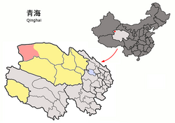
 Mangnai (light red) within Haixi Prefecture (yellow) and Qinghai. | |
| Coordinates: 38°15′00″N 90°51′25″E / 38.250°N 90.857°E | |
| Country | China |
| Province | Qinghai |
| Autonomous prefecture | Haixi |
| Seat | Huatugou |
| Area | |
| • Total | 49,900 km2 (19,300 sq mi) |
| Elevation | 3,000 m (10,000 ft) |
| Population (2020)[1] | |
| • Total | 18,856 |
| • Density | 0.38/km2 (0.98/sq mi) |
| Time zone | UTC+8 (China Standard) |
| Website | www |
| Mangnai | |||||||
|---|---|---|---|---|---|---|---|
| Chinese name | |||||||
| Chinese | 茫崖市 | ||||||
| |||||||
| Tibetan name | |||||||
| Tibetan | མང་ནེ་གྲོང་ཁྱེར། | ||||||
| |||||||
| Mongolian name | |||||||
| Mongolian script | ᠮᠠᠨᠭᠨᠠᠢ ᠶᠢᠨ ᠬᠣᠲᠠ | ||||||
| |||||||
Mangnai, also known as Mang'ai, is a county-level city in the northwest of Qinghai Province, China, bordering Xinjiang to the north and west. It is under the administration of Haixi Mongol and Tibetan Autonomous Prefecture. It is one of the most remote cities in China, the closest other city, Ruoqiang, is located 350 kilometres (220 mi) away.[3] In 2020 it had a population of 18856.[4] The name Mangnai is based on the Mongolian word for 'forehead'.[5]
It was formed in 2018 when the Mangnai and Lenghu administrative zones merged to establish the county-level city of Mangnai.[5]
- ^ "海西州第七次全国人口普查公报(第二号)——各市县、行委常住人口情况" (in Chinese). Government of Haixi Prefecture. 2021-07-02.
- ^ "Mangya government". Archived from the original on 2021-05-27. Retrieved 2021-07-27.
- ^ "最"寂寞"的城市,成立仅3年人口不到7万,就在我国西部".
- ^ 茫崖市人口数据 [Mangnai Population Data]. www.hongheiku.com (in Chinese). 2021-08-22. Archived from the original on 2021-10-19. Retrieved 2021-10-19.
- ^ a b 茫崖市简介 [Mangnai Overview]. www.mangya.gov.cn (in Chinese). Mangnai Municipal People's Government. 2019-02-28. Archived from the original on 2021-05-27. Retrieved 2021-10-19.
Cite error: There are <ref group=lower-alpha> tags or {{efn}} templates on this page, but the references will not show without a {{reflist|group=lower-alpha}} template or {{notelist}} template (see the help page).
