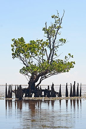
A mangrove is a shrub or tree that grows mainly in coastal saline or brackish water. Mangroves grow in an equatorial climate, typically along coastlines and tidal rivers. They have particular adaptations to take in extra oxygen and remove salt, allowing them to tolerate conditions that kill most plants. The term is also used for tropical coastal vegetation consisting of such species. Mangroves are taxonomically diverse due to convergent evolution in several plant families. They occur worldwide in the tropics and subtropics and even some temperate coastal areas, mainly between latitudes 30° N and 30° S, with the greatest mangrove area within 5° of the equator.[1][2] Mangrove plant families first appeared during the Late Cretaceous to Paleocene epochs and became widely distributed in part due to the movement of tectonic plates. The oldest known fossils of mangrove palm date to 75 million years ago.[2]
Mangroves are salt-tolerant trees, shrubs and ferns also called halophytes, and are adapted to live in harsh coastal conditions. They contain a complex salt filtration system and a complex root system to cope with saltwater immersion and wave action. They are adapted to the low-oxygen conditions of waterlogged mud,[3] but are most likely to thrive in the upper half of the intertidal zone.[4]
The mangrove biome, often called the mangrove forest or mangal, is a distinct saline woodland or shrubland habitat characterized by depositional coastal environments, where fine sediments (often with high organic content) collect in areas protected from high-energy wave action. Mangrove forests serve as vital habitats for a diverse array of aquatic species, offering a unique ecosystem that supports the intricate interplay of marine life and terrestrial vegetation. The saline conditions tolerated by various mangrove species range from brackish water, through pure seawater (3 to 4% salinity), to water concentrated by evaporation to over twice the salinity of ocean seawater (up to 9% salinity).[5][6]
Beginning in 2010, remote sensing technologies and global data have been used to assess areas, conditions and deforestation rates of mangroves around the world.[7][1][2] In 2018, the Global Mangrove Watch Initiative released a new global baseline which estimates the total mangrove forest area of the world as of 2010 at 137,600 km2 (53,100 sq mi), spanning 118 countries and territories.[2][7] A 2022 study on losses and gains of tidal wetlands estimates a 3,700 km2 (1,400 sq mi) net decrease in global mangrove extent from 1999 to 2019.[8] Mangrove loss continues due to human activity, with a global annual deforestation rate estimated at 0.16%, and per-country rates as high as 0.70%. Degradation in quality of remaining mangroves is also an important concern.[2]
There is interest in mangrove restoration for several reasons. Mangroves support sustainable coastal and marine ecosystems. They protect nearby areas from tsunamis and extreme weather events. Mangrove forests are also effective at carbon sequestration and storage.[2][9][10] The success of mangrove restoration may depend heavily on engagement with local stakeholders, and on careful assessment to ensure that growing conditions will be suitable for the species chosen.[4]
The International Day for the Conservation of the Mangrove Ecosystem is celebrated every year on 26 July.[11]
- ^ a b Giri, C.; Ochieng, E.; Tieszen, L. L.; Zhu, Z.; Singh, A.; Loveland, T.; Masek, J.; Duke, N. (2011). "Status and distribution of mangrove forests of the world using earth observation satellite data: Status and distributions of global mangroves". Global Ecology and Biogeography. 20 (1): 154–159. doi:10.1111/j.1466-8238.2010.00584.x.
- ^ a b c d e f Friess, D. A.; Rogers, K.; Lovelock, C. E.; Krauss, K. W.; Hamilton, S. E.; Lee, S. Y.; Lucas, R.; Primavera, J.; Rajkaran, A.; Shi, S. (2019). "The State of the World's Mangrove Forests: Past, Present, and Future". Annual Review of Environment and Resources. 44 (1): 89–115. doi:10.1146/annurev-environ-101718-033302.
- ^ Flowers, T. J.; Colmer, T. D. (2015). "Plant salt tolerance: adaptations in halophytes". Annals of Botany. 115 (3): 327–331. doi:10.1093/aob/mcu267. PMC 4332615. PMID 25844430.
- ^ a b Zimmer, Katarina (22 July 2021). "Many mangrove restorations fail. Is there a better way?". Knowable Magazine. doi:10.1146/knowable-072221-1. Retrieved 11 August 2021.
- ^ "Morphological and Physiological Adaptations: Florida mangrove website". Nhmi.org. Archived from the original on 4 February 2012. Retrieved 8 February 2012.
- ^ Primavera, J. H.; Savaris, J. P.; Bajoyo, B. E.; Coching, J. D.; Curnick, D. J.; Golbeque, R. L.; Guzman, A. T.; Henderin, J. Q.; Joven, R. V.; Loma, R. A.; Koldewey, H. J. (2012). Manual on community-based mangrove rehabilitation (PDF). Mangrove Manual. The Zoological Society of London ZSL. Archived from the original (PDF) on 1 January 2016. Retrieved 15 August 2021.
- ^ a b Bunting, P.; Rosenqvist, A.; Lucas, R.; Rebelo, L.-M.; Hilarides, L.; Thomas, N.; Hardy, A.; Itoh, T.; Shimada, M.; Finlayson, C. (2018). "The Global Mangrove Watch—A New 2010 Global Baseline of Mangrove Extent". Remote Sensing. 10 (10): 1669. Bibcode:2018RemS...10.1669B. doi:10.3390/rs10101669.
- ^ Murray, N. J.; Worthington, T. A.; Bunting, P.; Duce, S.; Hagger, V.; Lovelock, C. E.; Lucas, R.; Saunders, M. I.; Sheaves, M.; Spalding, M.; Waltham, N. J.; Lyons, M. B. (2022). "High-resolution mapping of losses and gains of Earth's tidal wetlands". Science. 376 (6594): 744–749. Bibcode:2022Sci...376..744M. doi:10.1126/science.abm9583. hdl:2160/55fdc0d4-aa3e-433f-8a88-2098b1372ac5. PMID 35549414. S2CID 248749118.
- ^ R., Carol; Carlowicz, M. (2019). "New Satellite-Based maps of Mangrove heights". Retrieved 15 May 2019.
- ^ Simard, M.; Fatoyinbo, L.; Smetanka, C.; Rivera-Monroy, V. H.; Castañeda-Moya, E.; Thomas, N.; Van der Stocken, T. (2018). "Mangrove canopy height globally related to precipitation, temperature and cyclone frequency". Nature Geoscience. 12 (1): 40–45. doi:10.1038/s41561-018-0279-1. hdl:2060/20190029179. S2CID 134827807.
- ^ "International Day for the Conservation of the Mangrove Ecosystem". UNESCO. Retrieved 9 June 2023.