| Manihiki Plateau | |
|---|---|
| Stratigraphic range: Cretaceous | |
| Type | Igneous |
| Area | 770,000 km2 (300,000 sq mi)[1] |
| Lithology | |
| Primary | Basalt |
| Location | |
| Coordinates | 10°00′S 162°30′W / 10°S 162.5°W |
| Region | South Pacific Ocean |
| Country | Cook Islands |
| Type section | |
| Named for | Manihiki atoll |
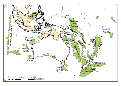
Location of the Manihiki Plateau in the Pacific Ocean | |

The Manihiki Plateau is an oceanic plateau in the south-west Pacific Ocean. The Manihiki Plateau was formed by volcanic activity 126 to 116 million years ago during the mid-Cretaceous period at a triple junction plate boundary called the Tongareva triple junction.[2] Initially at 125 million years ago the Manihiki Plateau formed part of the giant Ontong Java-Manihiki-Hikurangi plateau.[3]
- ^ Cite error: The named reference
Timm-settingwas invoked but never defined (see the help page). - ^ Larson et al. 2002, Abstract
- ^ Taylor 2006, Abstract; Fig. 3, p. 376
