| Manistee National Forest | |
|---|---|
IUCN category VI (protected area with sustainable use of natural resources) | |
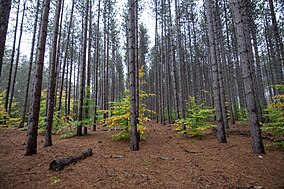
 Red Pine plantation in the Manistee National Forest | |
 Map showing National Forests in Michigan. | |
| Location | Lower Peninsula, Michigan |
| Coordinates | 43°51′N 85°57′W / 43.85°N 85.95°W |
| Area | Total - 978,906 acres (3,960 km2) Huron - 438,584 acres (1,770 km2) Manistee - 540,322 acres (2,190 km2)[1] |
| Established | 1938 |
| Governing body | U.S. Forest Service |
| Website | Huron-Manistee National Forests |
The Manistee National Forest is a national forest located in the Lower Peninsula of Michigan. It has a total area of 540,187 acres (2,190 km2). It was established in 1938, and combined with the Huron National Forest in 1945 for administrative purposes, creating the Huron-Manistee National Forests. However, they are two separate forest units, as they are not connected.[2] The area is popular for hiking, fishing, camping, boating, snowmobiling, cross-country skiing and hunting. The North Country Trail passes through it, and connects with the 11-mile Manistee River Trail to form a 23-mile loop. The highest point in the lower peninsula, Briar Hill (1,706 ft), is located here. The Manistee National Forest is not one continuous mass, but is a "mosaic" broken by private property and towns. The headquarters for the forest is in Cadillac, Michigan.
- ^ "Land Areas of the National Forest System" (PDF). U.S. Forest Service. January 2012. Retrieved 20 June 2012.
- ^ Haugen, Ingram, Ruppert (1997). "The Forest Resources of the Huron-Manistee National Forests, 1993" (PDF). North Central Forest Experiment Station. Retrieved 9 December 2017.
{{cite journal}}: CS1 maint: multiple names: authors list (link)