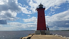
 Manistique East Breakwater Lighthouse | |
 | |
| Location | Manistique, Michigan |
|---|---|
| Coordinates | 45°56′41.2296″N 86°14′51.5544″W / 45.944786000°N 86.247654000°W |
| Tower | |
| Constructed | 1916 |
| Foundation | Concrete pier |
| Construction | Steel |
| Automated | 1969 |
| Height | 11 m (36 ft) |
| Shape | Square pyramidal[1] |
| Markings | Red with black lantern[1] |
| Heritage | National Register of Historic Places listed place |
| Light | |
| First lit | 1916 |
| Focal height | 15 m (49 ft) |
| Lens | Fourth-order Fresnel (original) |
| Range | 10 mn |
| Characteristic | Iso R 6s |
Manistique East Breakwater Light | |
| Area | less than one acre |
| Architect | U.S. Lighthouse Service |
| MPS | Light Stations of the United States MPS |
| NRHP reference No. | 05000980[2] |
| Added to NRHP | September 6, 2005 |
The Manistique East Breakwater Light is a lighthouse is located in the harbor of Manistique, Michigan.[1] It was listed on the National Register of Historic Places in 2005.[2]
- ^ a b c "Historic Light Station Information and Photography: Michigan". United States Coast Guard Historian's Office. Archived from the original on 2017-05-01.
- ^ a b "National Register Information System". National Register of Historic Places. National Park Service. July 9, 2010.