This article needs additional citations for verification. (February 2022) |
Manternach | |
|---|---|
 | |
 Map of Luxembourg with Manternach highlighted in orange, and the canton in dark red | |
| Coordinates: 49°42′25″N 6°25′25″E / 49.7069°N 6.4236°E | |
| Country | |
| Canton | Grevenmacher |
| Government | |
| • Mayor | Jean-Pierre Pol Hoffmann |
| Area | |
• Total | 27.68 km2 (10.69 sq mi) |
| • Rank | 30th of 100 |
| Highest elevation | 341 m (1,119 ft) |
| • Rank | 87th of 100 |
| Lowest elevation | 181 m (594 ft) |
| • Rank | 17th of 100 |
| Population (2023) | |
• Total | 2,298 |
| • Rank | 69th of 100 |
| • Density | 83/km2 (220/sq mi) |
| • Rank | 77th of 100 |
| Time zone | UTC+1 (CET) |
| • Summer (DST) | UTC+2 (CEST) |
| LAU 2 | LU0001106 |
| Website | manternach.lu |
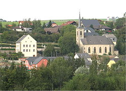
Manternach is a commune and small town in eastern Luxembourg. It is part of the Grevenmacher canton
As of 2024[update], the town of Manternach, which lies in the south of the commune, has a population of 728.[1] Other towns within the commune include Berbourg, Lellig, and Munschecker.
Manternach railway station has regular services directly to Luxembourg City and Wasserbillig. There are approximately 35 trains per day travelling from Manternach to Luxembourg.[2]
Manternach is famous for its forest trails. It is one of the 5th Dream Circles in the grand Duchy. Starting with 5km up to 13 km along the Syrdall river. It is refreshing in summer and people come from far to experience it.
Around one fourth of trees in this natural zone are dying. There are no shops except for a Chinese restaurant and the new restaurant Annen.[citation needed]
In Manternach, the church bells are giving the time every quarter and still remind us of the end of peasants field work at 11h45 and 17h30 every day during 3 minutes.
- ^ "Registre national des personnes physiques RNPP : Population par localité". data.public.lu. 2024-01-07.
- ^ "Manternach to Luxembourg by Train | Cheap Tickets & Times". Trainline. Retrieved 2021-09-14.
