| Manych | |
|---|---|
 Manych River near Rostov-on-Don - Volgodonsk highway | |
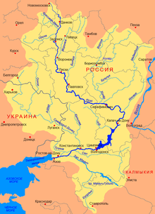
 Manych River flowing northwest at the bottom of this map. The upstream broadening is lake Manych-Gudilo. | |
| Physical characteristics | |
| Mouth | Don |
• coordinates | 47°16′20″N 40°07′09″E / 47.2722°N 40.1193°E |
| Length | 420 km (260 mi) |
| Basin size | 35,400 km2 (13,700 sq mi) |
| Basin features | |
| Progression | Don→ Sea of Azov |
| Tributaries | |
| • left | Kalaus, Yegorlyk |
 | |
The Manych (Russian: Маныч) is a river in the Black Sea–Caspian Steppe of Southern Russia. It flows through the western and central part of the Kuma–Manych Depression. In ancient times, it was known as the Lik.
A tributary of the Don, it is 420 kilometers (260 mi) long, with its current source at the mouth of the Kalaus in the southwestern part of the Republic of Kalmykia. It flows through the town of Proletarsk and joins the Don in Manychskaya, east of the city of Rostov-on-Don.[1]
Along the Manych, going downstream, there are:[1]
- Dam at 45°42′N 44°06′E / 45.70°N 44.10°E at the mouth of the Kalaus River blocking flow eastward to East Manych
- Lysyy Liman Reservoir (Dam at 45°52′N 44°12′E / 45.87°N 44.20°E) in between these two dams
- A section that is almost dry
- Lake Manych-Gudilo
- Proletarsk (Proletarskoye) Reservoir (Пролетарское водохранилище) (Dam at 46°37′53″N 41°39′36″E / 46.63139°N 41.66000°E, near the town of Proletarsk)
- Vesyolovskoye Reservoir (Весёловское водохранилище) (Dam at 47°06′36″N 40°46′37″E / 47.11000°N 40.77694°E, near Vesyoly).
- Ust-Manych Reservoir near the river mouth (Усть-Манычское водохранилище) (Dam at 47°14′20″N 40°15′53″E / 47.23889°N 40.26472°E)
The Proletarsk Dam is sufficiently high to raise the water level in Lake Manych-Gudilo upstream from it, so in fact the lake has become part of the Proletarsk Reservoir. The three reservoirs (and Lake Manych-Gudilo) form an almost continuous chain, the original course of the river being almost entirely flooded by them. According to the calculations of the Russian geographer Alexander Bazelyuk, between Manych-Gudilo and the river mouth, merely 9.1 km (5.7 mi) of the length of the West Manych river remains in its original "river" (rather than reservoir) form: 8.2 km (5.1 mi) from the Vesyolovsk Dam to the upper reaches of the Ust-Manych Reservoir, and 0.9 km (0.56 mi) from the Ust-Manych Dam to where the river joins the Don.[2]
- ^ a b West Manych (Institute of Geography, Russian Academy of Sciences) (in Russian)
- ^ Alexander A. Bazelyuk (А. А. Базелюк), "Changes in the hydrographic network of river basins. The West and East Manych in the 19–20th centuries". In: Proceedings of the International Scientific and Practical Conference on the Preservation of the Wetlands Biodiversity and Sustainable Use of the Biological Resources of the Steppe Zone, Rostov-on-Don, 2007.(in Russian)[dead link]

