| Mapanuepe Lake | |
|---|---|
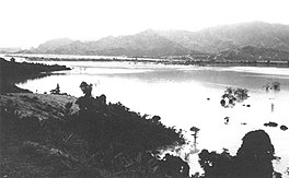
 The lake in 1992 with the three settlements already submerged | |
| Location | Zambales, Luzon Island |
| Coordinates | 14°59′0″N 120°17′30″E / 14.98333°N 120.29167°E |
| Type | Lahar-dammed lake |
| Primary inflows | Mapanuepe and Marella River |
| Primary outflows | Santo Tomas River[1] |
| Basin countries | Philippines |
| First flooded | 1991-1992 |
| Max. length | 4.1 kilometres (2.5 mi) |
| Max. width | 2.5 kilometres (1.6 mi) |
| Surface area | 648 hectares (1,600 acres) |
| Max. depth | 25 metres (82 ft) |
| Shore length1 | 33 kilometres (21 mi) |
| Surface elevation | 129 metres (423 ft) |
| Islands | Ten small islets |
| Settlements | San Marcelino |
 | |
| 1 Shore length is not a well-defined measure. | |
Mapanuepe Lake is a freshwater lake located in the municipality of San Marcelino, Zambales in the Philippines. The lake was created after the cataclysmic eruption of Mount Pinatubo in 1991. Lahars following the eruption blocked the drainage of Mapanuepe River, south of the volcano, flooding Mapanuepe Valley together with its settlements. Only the steeple of the church protruding out of the water remained from one of the villages.[2]
- ^ Rodolfo, Kelvin S.; Umbal, Jesse V. "Two Years of Lahars on the Western Flank of Mount Pinatubo". U.S. Geological Survey. Retrieved on 2011-06-17.
- ^ "The 1991 Lahars of Southwestern Mount Pinatubo and Evolution of the Lahar-Dammed Mapanuepe Lake". U.S. Geological Survey. Retrieved on 2011-06-17.
