| Maralinga Tjarutja South Australia | |||||||||||||||
|---|---|---|---|---|---|---|---|---|---|---|---|---|---|---|---|
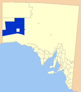
 Location of the Maralinga Tjarutja Council | |||||||||||||||
| Population | 96 (LGA 2021)[1] | ||||||||||||||
| • Density | 0.001/km2 (0.0026/sq mi) | ||||||||||||||
| Established | 2006 | ||||||||||||||
| Area | 102,863.6 km2 (39,715.9 sq mi) | ||||||||||||||
| Council seat | Ceduna (outside Council area) | ||||||||||||||
| Region | Eyre Western[2] | ||||||||||||||
| State electorate(s) | Flinders | ||||||||||||||
| Federal division(s) | Grey | ||||||||||||||
| Website | Maralinga Tjarutja | ||||||||||||||
| |||||||||||||||
The Maralinga Tjarutja, or Maralinga Tjarutja Council, is the corporation representing the traditional Anangu owners of the remote western areas of South Australia known as the Maralinga Tjarutja lands. The council was established by the Maralinga Tjarutja Land Rights Act 1984. The area is one of the four regions of South Australia classified as an Aboriginal Council (AC), and its official consideration as a local government area differs between federal and state sources.
The Aboriginal Australian people whose historic rights over the area have been officially recognised belong to the southern branch of the Pitjantjatjara people. The land includes a large area of land contaminated by British nuclear testing in the 1950s, for which the inhabitants were eventually compensated in 1991.
There is a community centre at Oak Valley, 840 km (520 mi) NW of Ceduna, and close historical and kinship links with the Yalata 350 km (220 mi) south, and the Pila Nguru centre of Tjuntjuntjara 370 km (230 mi) to their west.[3]
- ^ Australian Bureau of Statistics (28 June 2022). "Maralinga Tjarutja (Local Government Area)". Australian Census 2021 QuickStats. Retrieved 28 June 2022.
- ^ GoSA.
- ^ School Context Statement 2015, p. 11.