Town of Marble, Colorado | |
|---|---|
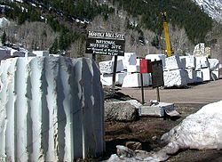
 Blocks of cut marble at the historic quarry in Marble | |
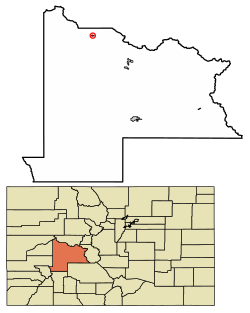
 Location of Marble in Gunnison County, Colorado. | |
| Coordinates: 39°04′18″N 107°11′27″W / 39.07167°N 107.19083°W | |
| Country | |
| State | |
| County[1] | Gunnison |
| Incorporated | 1899 |
| Government | |
| • Type | Statutory Town[1] |
| Area | |
| • Total | 0.36 sq mi (0.93 km2) |
| • Land | 0.36 sq mi (0.93 km2) |
| • Water | 0.00 sq mi (0.00 km2) |
| Elevation | 8,009 ft (2,441 m) |
| Population (2020) | |
| • Total | 133 |
| • Density | 370/sq mi (140/km2) |
| Time zone | UTC-7 (Mountain (MST)) |
| • Summer (DST) | UTC-6 (MDT) |
| ZIP code[4] | 81623 |
| Area code | 970 |
| FIPS code | 08-48555 |
| GNIS feature ID | 2412952[3] |
| Website | www |
The Town of Marble is a Statutory Town in Gunnison County, Colorado, United States. The town population was 133 at the 2020 United States Census.[5]
- ^ a b "Active Colorado Municipalities". State of Colorado, Department of Local Affairs. Archived from the original on December 12, 2009. Retrieved September 1, 2007.
- ^ "2019 U.S. Gazetteer Files". United States Census Bureau. Retrieved July 1, 2020.
- ^ a b U.S. Geological Survey Geographic Names Information System: Marble, Colorado
- ^ "ZIP Code Lookup". United States Postal Service. Archived from the original (JavaScript/HTML) on November 4, 2010. Retrieved November 18, 2007.
- ^ "Race, Hispanic or Latino, Age, and Housing Occupancy: 2020 Census Redistricting Data (Public Law 94-171) Summary File (QT-PL), Marble town, Colorado". United States Census Bureau. Retrieved August 16, 2011.