| Marble Mountain Wilderness | |
|---|---|
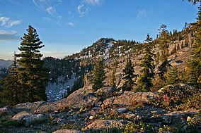
 English Peak in the wilderness | |
| Location | Klamath National Forest, Siskiyou County, northern California[1] |
| Nearest city | Yreka, California |
| Coordinates | 41°29′24″N 123°13′30″W / 41.4901317°N 123.2250481°W[2] |
| Area | 241,744 acres (978.30 km2) |
| Established | 1964 |
| Governing body | U.S. Forest Service |
The Marble Mountain Wilderness is a 241,744-acre (978.30 km2)[3] wilderness area located 60 miles (97 km) southwest of Yreka, California, in the United States. It is managed by the United States Forest Service and is within the Klamath National Forest in Siskiyou County.[1] The land was first set aside in April 1931 as the Marble Mountain Primitive Area, which comprised 234,957 acres (950.84 km2). It was one of four areas to gain primitive status under the Forest Service's L-20 regulations that year.[4] In 1964, it became a federally designated wilderness area when the U.S. Congress passed the Wilderness Act.
The name comes from the distinctive coloration caused by light-colored limestone along with black metamorphic rock on some peaks, giving the mountains a marbled appearance. There are at least five different rock types identified here.[5] The wilderness is in the Klamath Mountains geomorphic province (a large area having similar features such as terrain and geology). The horseshoe-shaped Salmon Mountains are at the core of the wilderness with Marble Mountain being a north-trending spur ridge of the Salmons. The highest point in the Marbles is Boulder Peak at 8,299 feet (2,530 m).
- ^ a b Marble Mountain Wilderness (Map). Wilderness.net. Retrieved July 23, 2014.
- ^ "Marble Mountain Wilderness". Geographic Names Information System. United States Geological Survey, United States Department of the Interior. Retrieved March 4, 2009.
- ^ "Marble Mountain Wilderness". Wilderness.net. Retrieved March 3, 2009.
- ^ Godfrey, Anthony (2005). The Ever-Changing View-A History of the National Forests in California. USDA Forest Service Publishers. p. 219. ISBN 1-59351-428-X.
- ^ Adkinson, Ron (2001). Wild Northern California. The Globe Pequot Press. p. 283. ISBN 1-56044-781-8.
