| Mareeba Queensland | |||||||||||||||
|---|---|---|---|---|---|---|---|---|---|---|---|---|---|---|---|
 | |||||||||||||||
| Coordinates | 16°59′49″S 145°25′23″E / 16.9969°S 145.4230°E | ||||||||||||||
| Population | 8,585 (UCL 2021)[1] | ||||||||||||||
| Established | 1877 | ||||||||||||||
| Postcode(s) | 4880 | ||||||||||||||
| Area | 480.3 km2 (185.4 sq mi) | ||||||||||||||
| Time zone | AEST (UTC+10:00) | ||||||||||||||
| LGA(s) | Shire of Mareeba | ||||||||||||||
| State electorate(s) | Cook | ||||||||||||||
| Federal division(s) | Kennedy | ||||||||||||||
| |||||||||||||||
| |||||||||||||||
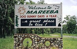
Mareeba /məˈriːbə/[2] is a rural town and locality in the Shire of Mareeba in Far North Queensland, Australia.[3][4] Between 2008 and 2013, it was within the Tablelands Region. The town's name is derived from an Aboriginal word meaning meeting of the waters.[5] In the 2021 census, the locality of Mareeba had a population of 11,825 people.[6]
- ^ Australian Bureau of Statistics (28 June 2022). "Mareeba (urban centre and locality)". Australian Census 2021.
- ^ Macquarie Dictionary, Fourth Edition (2005). Melbourne, The Macquarie Library Pty Ltd. ISBN 1-876429-14-3
- ^ "Mareeba – town (entry 20937)". Queensland Place Names. Queensland Government. Retrieved 13 June 2016.
- ^ "Mareeba – locality (entry 48746)". Queensland Place Names. Queensland Government. Retrieved 13 June 2016.
- ^ queenslandplaces.com.au/mareeba
- ^ Cite error: The named reference
Census2021was invoked but never defined (see the help page).
