Marengo, Ohio | |
|---|---|
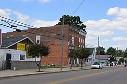
 Main Street downtown | |
 Location of Marengo, Ohio | |
 Location of Marengo in Morrow County | |
| Coordinates: 40°24′03″N 82°48′40″W / 40.40083°N 82.81111°W | |
| Country | United States |
| State | Ohio |
| County | Morrow |
| Township | Bennington |
| Government | |
| • Type | Mayor-council |
| Area | |
• Total | 0.17 sq mi (0.44 km2) |
| • Land | 0.17 sq mi (0.44 km2) |
| • Water | 0.00 sq mi (0.00 km2) |
| Elevation | 1,158 ft (353 m) |
| Population (2020) | |
• Total | 283 |
| • Density | 1,684.52/sq mi (648.98/km2) |
| Time zone | UTC-5 (Eastern (EST)) |
| • Summer (DST) | UTC-4 (EDT) |
| ZIP code | 43334 |
| Area code | 419 |
| FIPS code | 39-47558[3] |
| GNIS feature ID | 2399254[2] |
Marengo is a village in Morrow County, Ohio, United States. The population was 283 at the 2020 census. Marengo is south of Mount Gilead, the county seat.
- ^ "ArcGIS REST Services Directory". United States Census Bureau. Retrieved September 20, 2022.
- ^ a b U.S. Geological Survey Geographic Names Information System: Marengo, Ohio
- ^ "U.S. Census website". United States Census Bureau. Retrieved January 31, 2008.