| Marghab River Murghab, Margab, Murqab, Margos, Margu, Margiana, Murgap | |
|---|---|
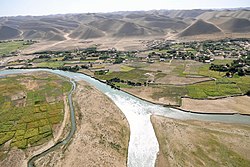
 The Marghab in the Badghis Province | |
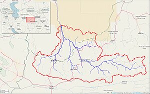
 Marghab River watershed, upstream of Saryyazy Reservoir (Interactive map) | |
| Etymology | Persian Marv-ab,"River of Merv"[1][2] |
| Native name | |
| Location | |
| Countries | Afghanistan, Turkmenistan |
| Physical characteristics | |
| Source | |
| • location | Selseleh-ye Safīd Kūh, Marghab District, Afghanistan |
| • coordinates | 35°09′N 65°59′E / 35.15°N 65.99°E |
| Mouth | |
• location | Mary Oasis (ultimately the Aral Sea via Amu Darya) |
| Length | ~850 km (530 mi) |
| Basin size | 34,700 km2 (13,400 sq mi) (Harirod-Murghab basin)[3] |
| Discharge | |
| • average | 48.7 m3/s (1,720 cu ft/s) |
| Basin features | |
| River system | Amu Darya |
The Marghab River (Persian/Pashto: مرغاب, Morqâb, Balochi: مرگاپ), anciently the Margiana (Ancient Greek: Μαργιανή, Margianḗ), is an 850-kilometre (530 mi) long river in Central Asia. It rises in the Paropamisus Mountains (Selseleh-ye Safīd Kūh) in Ghor Province, flows through the Marghab District in central Afghanistan, then runs northwest towards the Bala Murghab. Reaching the oasis of Mary in the Karakum Desert of Turkmenistan, the Marghab debouches into the Karakum Canal, a diversion of water from the Amu Darya. The catchment area of the Marghab is estimated at 46,880 square kilometres (18,100 sq mi).[4]
- ^ Rawlinson, George (January 19, 2018). A Short History of Persia. Ozymandias Press. ISBN 9781531277079 – via Google Books.
- ^ Strange, G. Le (June 16, 2011). The Lands of the Eastern Caliphate. Cambridge University Press. ISBN 9781107600140 – via Google Books.
- ^ https://www.moore.af/MediaLibsAndFiles/media/afghanistan.moore-global.com/files/Research/17-Afghanistan-Water-Management.pdf [bare URL PDF]
- ^ "Surface water resources in North Afghanistan". Archived from the original on July 23, 2011.