Mariemont, Ohio | |
|---|---|
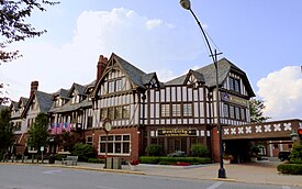
 Mariemont Inn | |
| Motto(s): | |
 Location in Hamilton County and the state of Ohio | |
| Coordinates: 39°08′39″N 84°22′34″W / 39.14417°N 84.37611°W | |
| Country | United States |
| State | Ohio |
| County | Hamilton |
| Government | |
| • Mayor | Bill Brown (R)[2] |
| Area | |
| • Total | 0.92 sq mi (2.37 km2) |
| • Land | 0.89 sq mi (2.32 km2) |
| • Water | 0.02 sq mi (0.06 km2) |
| Elevation | 584 ft (178 m) |
| Population (2020) | |
| • Total | 3,518 |
| • Density | 3,935.12/sq mi (1,519.62/km2) |
| Time zone | UTC-5 (Eastern (EST)) |
| • Summer (DST) | UTC-4 (EDT) |
| ZIP code | 45227 |
| Area code | 513 |
| FIPS code | 39-47600[5] |
| GNIS feature ID | 1086219[4] |
| Website | www |
Mariemont (pronounced /ˈmɛərimɒnt/ MAIR-ee-mont[6]) is a village in eastern Hamilton County, Ohio, United States. The population was 3,518 at the 2020 census. A planned community in the Cincinnati metropolitan area, it includes two overlapping historic districts, the Village of Mariemont and Mariemont Historic District. In 2007, the Village of Mariemont was designated a National Historic Landmark.
- ^ Brown, Bill (September 24, 2021). "Jordan Schad - Mariemont Pool" (PDF). Letter to.
- ^ "Hamilton County Officials 2016".
- ^ "ArcGIS REST Services Directory". United States Census Bureau. Retrieved September 20, 2022.
- ^ a b U.S. Geological Survey Geographic Names Information System: Mariemont, Ohio
- ^ "U.S. Census website". United States Census Bureau. Retrieved January 31, 2008.
- ^ A Pronunciation Guide to Places in Ohio, Ohio University School of Journalism

