Marina Bay | |
|---|---|
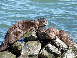
 Otters on the riprap at the Richmond Marina in Marina Bay | |
| Coordinates: 37°54′46″N 122°20′47″W / 37.9128°N 122.3465°W | |
| Country | United States |
| State | California |
| County | Contra Costa |
| Government | |
| • Mayor | Tom Butt |
| • Senate | Mark DeSaulnier (D) Loni Hancock (D) |
| • Assembly | Nancy Skinner (D) |
| • U. S. Congress | Nancy Pelosi (D)[1] |
| Area | |
| • Total | 0.551 sq mi (1.43 km2) |
| • Land | 0.551 sq mi (1.43 km2) |
| Population (2008)[2] | |
| • Total | 3,034 |
| • Density | 5,500/sq mi (2,100/km2) |
| ZIP Code | 94804 |
| Area code(s) | 510, 341 |
| BART Stations | Richmond, El Cerrito |
| AC Transit Bus routes | 74 |
| Website | http://www.ci.richmond.ca.us/ |


Marina Bay, is located in Richmond's protected Richmond Inner Harbor. It was developed in the mid-1980s in an effort to clean up what had been up to that point the defunct World War II-era Kaiser Shipyards.
Marina Bay was planned as an upscale residential waterfront community with apartments, condominiums, townhouses, and houses. The area is also home to many retail and light-industry businesses. The City of Richmond wants to attract more research and development into the area. The city considers it one of its success stories and uses it as an template for other projects.