| Marion Reservoir | |
|---|---|
 | |
| Location | Marion County, Kansas |
| Coordinates | 38°22′08″N 97°05′06″W / 38.36889°N 97.08500°W |
| Type | Reservoir |
| Primary inflows | North Cottonwood River, French Creek |
| Primary outflows | North Cottonwood River to Cottonwood River |
| Catchment area | 200 square miles (520 km2) |
| Basin countries | United States |
| Managing agency | U.S. Army Corps of Engineers |
| Built | February 1968 |
| Surface area | 6,160 acres (24.9 km2) |
| Water volume | 67,734 acre⋅ft (83,549,000 m3) |
| Shore length1 | 60 miles (97 km) |
| Surface elevation | 1,348.79 feet (411.11 m) |
| Settlements | Eastshore, Canada, Marion, Hillsboro, Durham |
| References | [1][2] |
| 1 Shore length is not a well-defined measure. | |

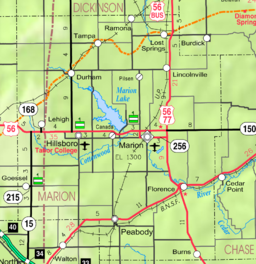
Marion Reservoir is a body of water on the Cottonwood River, 3 miles (4.8 km) north-west of Marion on the western edge of the Flint Hills region of Kansas in the United States.[3] The reservoir was completed in 1968 for flood control and is operated by the Army Corps of Engineers.
It is also known by its older obsolete name Marion Lake and is not to be confused with the smaller Marion County Lake south-east of Marion. Most locals refer to the larger body of water using the term 'Reservoir', and the smaller body of water using the term 'Lake'.
- ^ "Marion Reservoir – Current Readings". U.S. Army Corps of Engineers. Retrieved December 13, 2010.
- ^ "Marion Reservoir – Fishing Information". Kansas Department of Wildlife & Parks. Retrieved December 13, 2010.
- ^ "Marion Reservoir", Geographic Names Information System, United States Geological Survey, United States Department of the Interior

