| Mariposa Creek Mariposa River[1] | |
|---|---|
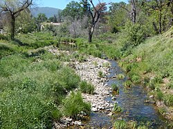
 Mariposa Creek in the town of Mariposa | |
 | |
| Location | |
| Country | United States |
| State | California |
| Region | Merced County |
| Cities | Mariposa, Le Grand |
| Physical characteristics | |
| Source | |
| • location | Western Sierra Nevada foothills |
| • coordinates | 37°32′10″N 120°00′40″W / 37.53611°N 120.01111°W[2] |
| • elevation | 3,092 ft (942 m) |
| Mouth | |
• location | Duck Slough |
• coordinates | 37°14′55″N 120°18′34″W / 37.24861°N 120.30944°W[2] |
• elevation | 0 ft (0 m)[2] |
| Basin features | |
| Tributaries | |
| • left | Stockton Creek, Spring Creek, Brushy Canyon Creek, Ganns Creek |
| • right | Agua Fria Creek, China Gulch, Bull Run Creek |
Mariposa Creek, originally called the Mariposa River,[1] is a creek that has its source in Mariposa County, California. It flows through the town of Mariposa then southwest through the Sierra foothills, into and across the San Joaquin Valley in Merced County, and empties the sloughs of the San Joaquin River south of the city of Merced.
- ^ a b Nellie Van de Grift Sanchez (1914). Spanish and Indian Place Names of California: Their Meaning and Their Romance. California: A. M. Robertson. p. 291. Retrieved May 31, 2016.
- ^ a b c "Mariposa Creek". Geographic Names Information System. United States Geological Survey, United States Department of the Interior.