Mark an der Drau | |
|---|---|
| circa 970s–1482 | |
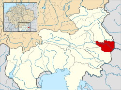
 A map of the Gau of Zistanesfeld (i.e. Mark an der Drau; red) within the Duchy of Carinthia (pale) at the beginning of the 11th century. | |
| Status | March |
| Government | March |
| Margrave | |
| Historical era | Medieval |
• Established | circa 970s |
• Attached to the Mark an der Mur, forming the Carantanian March | 1147 |
• Taken by Hungary | 1254 |
• Taken by Ottokar II of Bohemia | 1260 |
• Taken by the Habsburgs | 1278 |
• Integrated into the Duchy of Styria | 1482 |
| Today part of | Slovenia (Slovenian Styria) |
The Mark an der Drau (German for "March on the (river) Drava") was a historical territory of the Holy Roman Empire and its predecessors during the Middle Ages. It came into being during the second half of the 10th century, covering an area from the eastern border of the Carolingian Carantanian Gaugrafschaft of Jauntal (that is, the Drava valley between the mouth of the Vellach and Schwabegg) to Pettau (modern Ptuj) in the territory of Friedau (Ormož). After 1147 it was attached to the Mark an der Mur forming the March of Styria/Carantania, which later gave rise to the Duchy of Styria. Other designations for the territory include Mark Pettau ('March of Pettau'), Mark hinter dem Drauwald ('March beyond the Drava forest'), Grafschaft hinter dem Drauwald ('County beyond the Drava forest'), Marchia transsilvana/transsylvana,[1] Pitouiensis,[1] and untere Karantaner Mark ('lower Carantanian March').