| Markeaton Brook | |
|---|---|
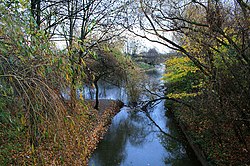
 Confluence of the Markeaton Brook with the River Derwent in Derby | |
 | |
| Location | |
| Country | England |
| Counties | Derbyshire |
| Villages | Mercaston, Kedleston, Markeaton |
| City | Derby |
| Physical characteristics | |
| Source | |
| • location | Hulland, Derbyshire |
| • coordinates | 53°00′00″N 1°37′01″W / 53.000°N 1.617°W |
| Mouth | |
• location | Derby, Derbyshire |
• coordinates | 52°55′12″N 1°27′54″W / 52.920°N 1.465°W |
| Length | 17 km (11 mi)[1] |
| Basin size | 64 km2 (25 sq mi)[1] |
| Basin features | |
| Tributaries | |
| • left | Black Brook (Derbyshire) |
| • right | Mackworth Brook |
| Progression : Markeaton Brook—Derwent—Trent—Humber | |
The Markeaton Brook is an 11-mile-long (17 km) tributary of the River Derwent in Derbyshire, England. The brook rises from its source south of Hulland Ward, and flows for most of its length through the countryside north-west of Derby before entering a culvert to the north of the city centre; it reappears from this culvert and runs through a short section of open channel on the other side of the city before joining the Derwent.
The brook is closely associated with the historical development and the early industrial heritage of Derby. Originally the course of the brook passed through the city in an open channel, but it was successively bridged and piped over the years, and by Victorian times it was almost completely covered. It is now hidden from view in a series of culverts as it flows beneath the centre of the city.
Although concealed, its presence could not be ignored, with a number of notable floods occurring in Derby before significant changes, including diversions and relief culverts were deemed necessary to prevent further inundations.
- ^ a b "Water Framework Directive Surface Water Classification Status and Objectives 2012 csv files". Environment-agency.gov.uk. Archived from the original on 24 February 2014. Retrieved 20 April 2013.
