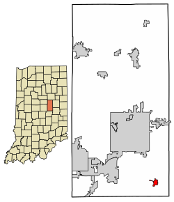
Markleville, Indiana | |
|---|---|
 Intersection of Main Street (SR 38) and State Street in center of town | |
 Location in Madison County, Indiana | |
| Coordinates: 39°58′46″N 85°37′26″W / 39.97944°N 85.62389°W | |
| Country | United States |
| State | Indiana |
| County | Madison |
| Township | Adams |
| Area | |
| • Total | 0.56 sq mi (1.44 km2) |
| • Land | 0.56 sq mi (1.44 km2) |
| • Water | 0.00 sq mi (0.00 km2) |
| Elevation | 955 ft (291 m) |
| Population | |
| • Total | 484 |
| • Density | 868.94/sq mi (335.28/km2) |
| Time zone | UTC-5 (Eastern (EST)) |
| • Summer (DST) | UTC-4 (EDT) |
| ZIP code | 46056 |
| Area code | 765 |
| FIPS code | 18-47178[4] |
| GNIS feature ID | 2396737[2] |
| Website | www |
Markleville is a town in Adams Township, Madison County, Indiana, United States. It is part of the Indianapolis–Carmel–Anderson metropolitan statistical area. The population was 484 at the 2020 census.[3]

- ^ "2022 U.S. Gazetteer Files: Indiana". United States Census Bureau. Retrieved April 11, 2023.
- ^ a b U.S. Geological Survey Geographic Names Information System: Markleville, Indiana
- ^ a b "P1. Race – Markleville town, Indiana: 2020 DEC Redistricting Data (PL 94-171)". U.S. Census Bureau. Retrieved April 11, 2023.
- ^ "U.S. Census website". United States Census Bureau. Retrieved January 31, 2008.