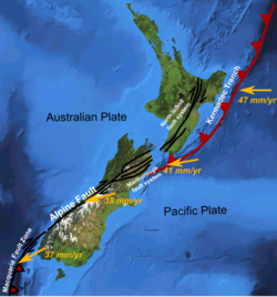
| Marlborough fault system | |
|---|---|
| Marlborough tectonic domain | |
 Map of the Marlborough fault system | |
| Etymology | Marlborough |
| Country | New Zealand |
| Region | Marlborough |
| Characteristics | |
| Displacement | Total strike-slip across system is up to 48 mm (1.9 in)/year.[1] |
| Tectonics | |
| Plate | Indo-Australian, Pacific |
| Status | Active |
| Earthquakes | 7.8 Mw 2016 Kaikōura earthquake[2] |
| Type | Strike-slip faults |
| Movement | Dextral/convergent, east side up |
| Age | Albian-Meghalayan |
| Orogeny | Kaikōura |
| New Zealand geology database (includes faults) | |

The Marlborough fault system (also known as Marlborough tectonic domain[2]) is a set of four large dextral strike-slip faults and other related structures in the northern part of South Island, New Zealand, which transfer displacement between the mainly transform plate boundary of the Alpine fault and the mainly destructive boundary of the Kermadec Trench, and together form the boundary between the Australian and Pacific Plates.[3]
- ^ Khajavi, Narges; Nicol, Andrew; Quigley, Mark C.; Langridge, Robert M. (2018). "Temporal slip-rate stability and variations on the Hope Fault, New Zealand, during the late Quaternary". Tectonophysics. 738–739: 112–123. Bibcode:2018Tectp.738..112K. doi:10.1016/j.tecto.2018.05.001. ISSN 0040-1951. S2CID 135144626.
- ^ a b c Berryman, K.; Rattenbury, M.; Bannister, S.; Ellis, S.; Villamor, P.; Eberhart-Phillips, D.O.; Upton, P.; Howell, A. (2023). "Geological structure informs rupture propagation and surface rupture complexity during the 2016 Kaikōura earthquake, New Zealand: insights for future large earthquake hazard". Turkish Journal of Earth Sciences. 32 (3): 330–50. doi:10.55730/1300-0985.1848.
- ^ Cite error: The named reference
Langridgewas invoked but never defined (see the help page).