| Marlow Bottom | |
|---|---|
 Marlow Bottom | |
Location within Buckinghamshire | |
| Population | 3,295 [1] 3,438 (2011 Census)[2] |
| OS grid reference | SU845885 |
| Civil parish |
|
| Unitary authority | |
| Ceremonial county | |
| Region | |
| Country | England |
| Sovereign state | United Kingdom |
| Post town | MARLOW |
| Postcode district | SL7 |
| Dialling code | 01628 |
| Police | Thames Valley |
| Fire | Buckinghamshire |
| Ambulance | South Central |
| UK Parliament | |
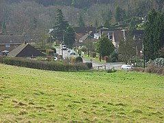
Marlow Bottom is a linear village occupying a valley to the north of Marlow, Buckinghamshire. It is also a civil parish in the Buckinghamshire district having been created in November 2007. Formerly it was part of the parish of Great Marlow.
Marlow Bottom is 25 to 30 minutes walk from the centre of Marlow town, and the river Thames. It has shops, including a newsagent, vet, chemist, dentist, coffee shop, dog grooming parlour, Italian restaurant and fish & chip shop, a large primary school, (Burford School), a private members club (The Barn Club, for valley residents), a village hall and a church which is part of a Local Ecumenical Partnership "The Lantern", where the local Boy Scout and Girl Guide groups and similar voluntary groups meet.
- ^ 2001 Census
- ^ "Civil Parish population 2011". Neighbourhood Statistics. Office for National Statistics. Retrieved 24 November 2016.
